

What Is a Volcano? How Volcanoes Work, Their Parts and Main Types
Volcanoes are not simply mountains that occasionally release lava. They are places where magma, gases and rock fragments can reach the surface from inside the Earth. Some eruptions steadily build broad lava fields, others send ash high into the atmosphere, and some combine both kinds of activity.
In short, a volcano is a vent or system of vents in the Earth’s crust, together with the landforms built by the lava, tephra and gases they release. A volcano’s appearance and the course of an eruption depend on factors including magma composition and viscosity, dissolved gases, the rate of magma supply and contact with water.
This guide explains what a volcano is, how it forms and why it erupts. It also separates three ideas that are often confused: the shape of the volcanic landform, its eruption style and its activity status. This makes it easier to distinguish a stratovolcano from a shield volcano, magma from lava, effusive from explosive eruptions, and active, dormant and extinct volcanoes.
Volcanoes at a glance
A volcano belongs to a system through which magma and gases move towards the surface. Magma is called lava once it reaches the surface. A volcano’s shape alone does not determine the style or strength of its next eruption.
| Question | Short answer |
|---|---|
| What is a volcano? | A vent or system of vents releasing lava, tephra and gases, and the landforms those materials build. |
| Magma versus lava | Magma is below the surface; once it emerges, it is called lava. |
| Main forms | Cinder cones, stratovolcanoes, shield volcanoes and lava domes; fissure systems also play an important role. |
| Why does it erupt? | Buoyancy and gas pressure help magma rise through fractures and weaknesses in the crust. |
| Can an eruption be predicted? | Signs of growing unrest can be detected, but the exact timing and course usually cannot be specified far in advance. |

Check out my YouTube channel and travel with me.
Follow the channel for videos, routes and practical travel inspiration.
Follow me here:
What’s up?
Enjoying my content?
Buy me a coffee at buycoffee.to/ondatravel and support the creation of more travel content.
Your support helps me create more practical guides, videos and travel inspiration.

What is a volcano, and where does magma come from?
According to the USGS Volcano Hazards Program, volcanoes are openings or vents through which lava, tephra, steam and other gases reach the Earth’s surface. However, the word does not refer only to the opening itself. In practice, it also describes the volcanic landform and the system beneath it: magma storage regions, pathways, fractures, conduits and successive layers of material deposited by eruptions.
Magma does not come from a vast ocean of liquid rock inside the Earth. It forms locally when part of the mantle or crust melts. Falling pressure, the addition of water and other volatile substances, or rising temperature can encourage melting. The resulting melt is usually less dense than surrounding rocks, allowing it to move upwards with the help of buoyancy and the pressure of dissolved gases.
Magma versus lava: the distinction worth remembering
Magma is a molten or partly molten mixture of rock material, crystals and gases below the surface. Once that material emerges, we call it lava. The distinction is primarily its location, rather than a particular temperature or composition.
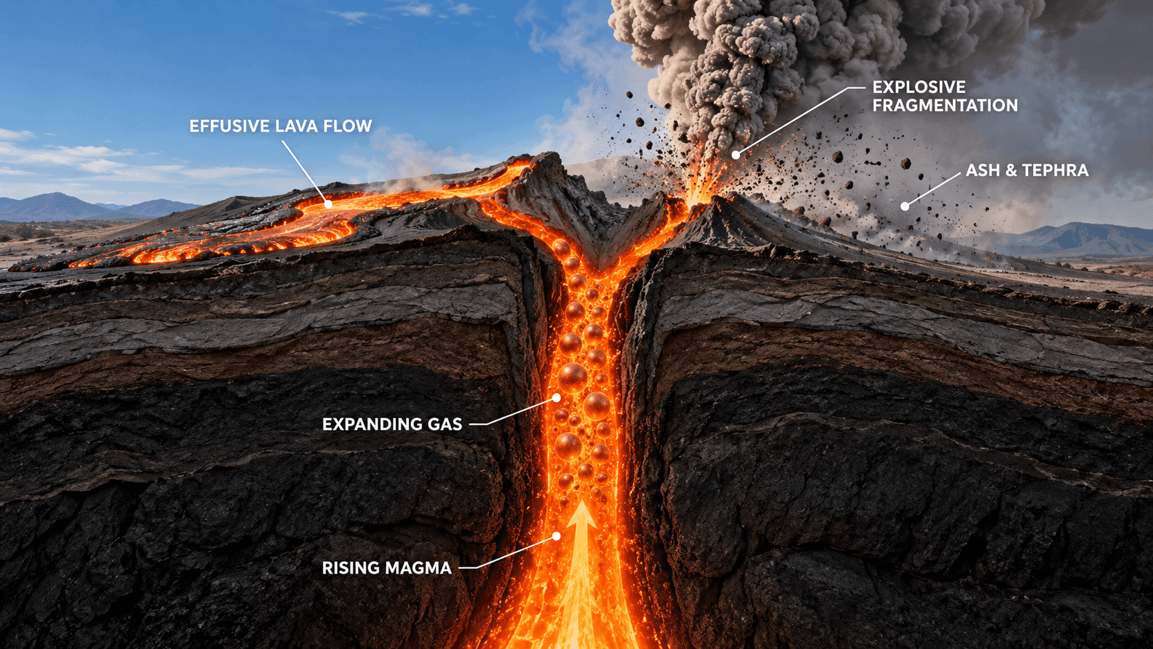
As pressure falls, gases begin to separate from magma, rather like bubbles appearing when a fizzy drink is opened. In low-viscosity magma, gas can escape more readily. In viscous magma, pressure may build until rock fractures and magma fragments violently. This is one of the major reasons why a relatively steady lava outpouring differs from an explosive eruption.
Where do volcanoes form?
Most volcanic activity is related to tectonic plate movement, but not all volcanoes form in the same way.
- Rifts and mid-ocean ridges: plates move apart, pressure in the mantle decreases, and magma can enter the developing fractures. Iceland is unusual because part of the Mid-Atlantic Ridge lies above sea level.
- Subduction zones: one plate descends beneath another. Water released from the descending plate helps mantle rocks melt. This produces volcanic arcs, including those around the Pacific Ring of Fire.
- Hotspots: hot material rises within a plate, away from its boundaries. Hawaii is a classic example. Iceland combines rifting with an anomalously hot mantle.
Volcanoes can form on land, underwater and beneath glaciers. Their environment affects an eruption: magma-water interaction can increase fragmentation, while a subglacial eruption can melt enormous quantities of ice and trigger a sudden glacial flood.
How is a volcano built?
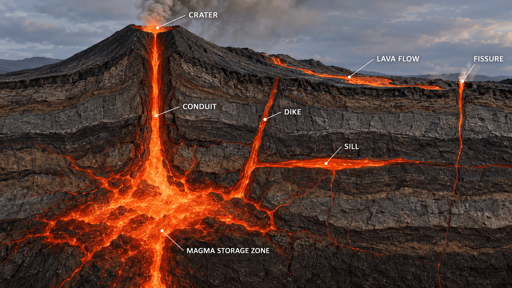
A school diagram usually shows one magma reservoir and a straight conduit leading to a crater. This is a useful simplification, but real systems can be considerably more complex. Magma can pause at several depths, intrude into rock as dikes and other bodies, and travel sideways for many kilometres.
Magma storage, conduit and crater
A magma reservoir is a region within the crust where magma accumulates or moves. A conduit provides a pathway towards the surface, while a crater is a depression associated with an eruptive vent. A single system can contain many conduits and craters; the next eruption does not necessarily occur at the previous vent.
Fissures and fissure systems
An eruption need not emerge from a central cone. Magma can reach the surface along a long fracture, creating a row of craters and a broad lava field. This is particularly important in Iceland, where institutions describe entire volcanic systems, which may include a central volcano, fissure swarms and associated geothermal areas.
A caldera is not simply a large crater
A caldera is a large collapse structure that can form when substantial eruption or redistribution of underground magma weakens support for the overlying rock. It is not an ordinary crater, and not every caldera implies a supervolcano. I explain the mechanism and examples, from Santorini to Askja, in what a caldera is, how it forms and how it differs from a crater.

ICELAND
What is a caldera?
Explore how calderas form, why they differ from craters, and why the word does not automatically mean supervolcano.
Volcano types by shape
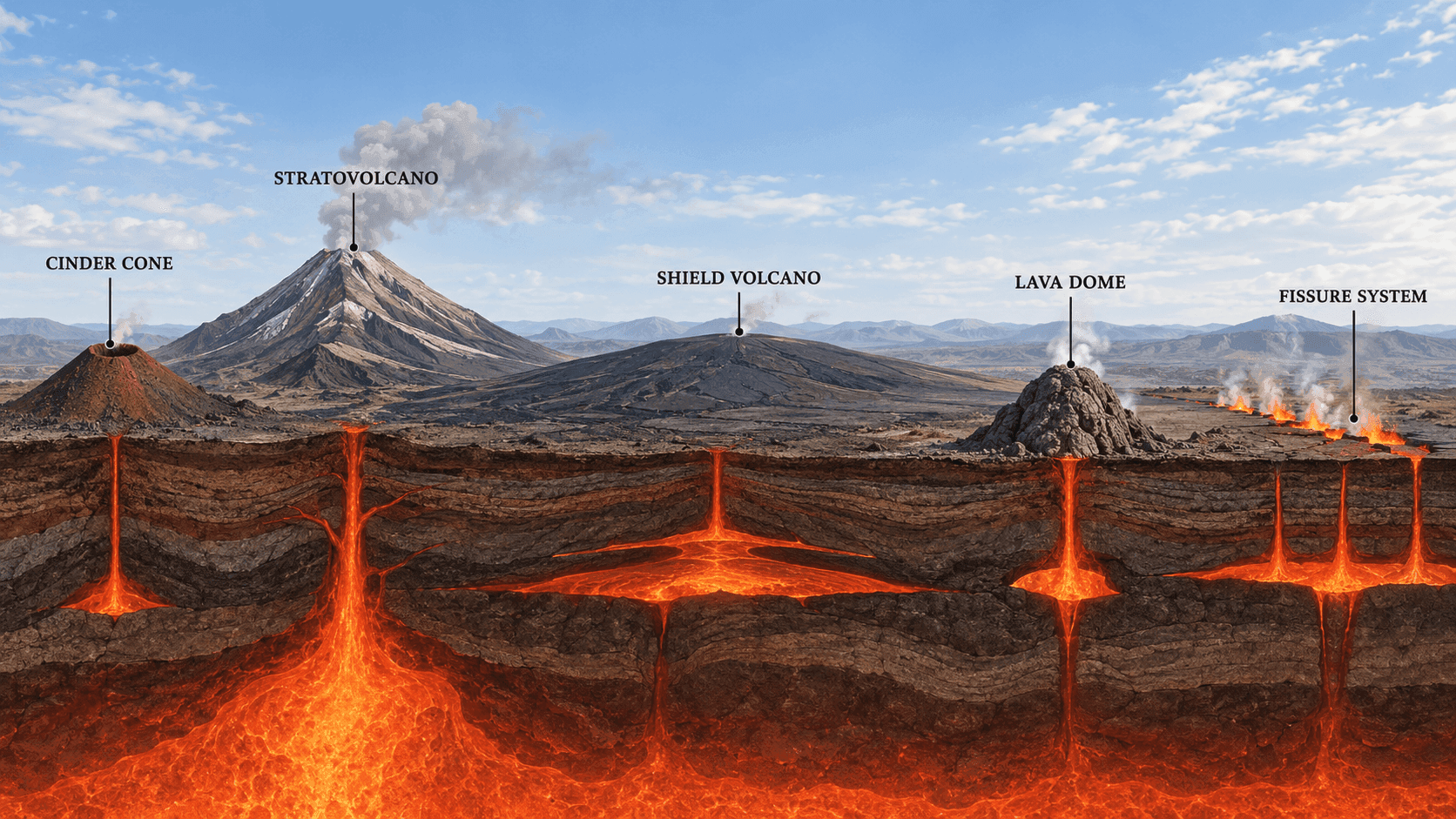
There is no single closed list of volcano categories. A volcano can be described by shape, material, environment, tectonic setting, number of eruptive episodes or eruption style. One volcano can therefore be a stratovolcano, a subglacial volcano and a polygenetic system at the same time.
| Form | Formation and appearance | Typical behaviour |
|---|---|---|
| Cinder cone | A small, steep cone of loose lava fragments around a vent. | Usually a comparatively short period of activity, with ejected scoria and bombs and lava outflows. |
| Stratovolcano | A large, steep volcano built from alternating layers of lava, ash and other deposits. | Both explosive and effusive eruptions are possible; hazards are complex. |
| Shield volcano | A broad, gently sloping landform built by repeated extensive flows of low-viscosity lava. | Effusive activity predominates, although other phenomena are not excluded. |
| Lava dome | A steep mass of highly viscous lava accumulating close to a vent. | Slow growth and potentially dangerous collapse. USGS notes that technically a dome is better considered an eruptive phenomenon than a separate type of whole volcano. |
| Fissure system | Lava emerges along a fracture or series of vents rather than a single central conduit. | Can create long crater rows and extensive lava fields, as in Iceland. |
USGS traditionally groups volcanoes into four main forms: cinder cones, stratovolcanoes, shield volcanoes and lava domes. More recent explanations from the same institution clarify that a dome may be part of a larger volcano. This is a useful reminder that classifications are descriptions, not rigid compartments.
Volcanic eruption types and styles
A volcano’s shape and its eruption style are different things. One system can behave differently at different times. USGS explains that eruption style depends on magma chemistry, temperature and crystal content, dissolved gases, the discharge rate and contact with water. As magma rises and pressure decreases, gases expand; activity can be effusive or explosive.
Effusive, explosive and mixed eruptions
In an effusive eruption, lava flows relatively freely from a vent or fissure. An explosive eruption violently fragments magma and rock, producing ash, pumice, bombs and sometimes pyroclastic flows. Many eruptions combine both processes or change style over time.
| Eruption style | Main characteristic | How to interpret it |
|---|---|---|
| Hawaiian | Fountains and extensive flows of fluid basaltic lava. | Generally towards the relatively steady, effusive end of the spectrum. |
| Icelandic | Outpourings along long fissures. | Can produce curtains of fire and extensive lava sheets. |
| Strombolian | Repeated short explosions. | Ejects incandescent lava fragments, lapilli and bombs. |
| Vulcanian | Short, violent explosions involving viscous magma. | Produces dense ash clouds and rock blocks. |
| Vesuvian | A strong, sustained eruption column. | A historical term referring to Vesuvius; boundaries with other categories are not sharp. |
| Peléan | Lava-dome growth and collapse. | Can generate extremely dangerous pyroclastic flows. |
| Plinian | A high, sustained column of ash and pumice. | A strongly explosive style that can affect a wide area. |
Style names help describe events, but nature does not always fit one label. An eruption may begin with fissure-fed lava effusion, enter a more explosive phase, or repeatedly change intensity.
The VEI scale: what does it actually measure?
The Volcanic Explosivity Index (VEI) is a relative eruption-explosivity scale developed by Chris Newhall and Stephen Self. It principally considers the volume of erupted material, eruption-column height and a qualitative description. It runs from 0 to 8 and is logarithmic in its higher ranges: each successive level represents roughly ten times the volume of tephra.
VEI is not a simple danger scale. An eruption with little explosive activity can be deadly close to a fissure, and a prolonged lava outpouring can destroy infrastructure despite a low VEI. The scale poorly represents the size of purely effusive eruptions, gas emissions and local effects such as avalanches, lahars or glacial floods.
Active, dormant and extinct volcanoes
The labels active, dormant and extinct are convenient, but do not mean precisely the same thing everywhere. The Global Volcanism Program often uses the term Holocene volcano: one that has been active during the Holocene, approximately the past 11,000–12,000 years. This is a geological criterion, not a statement that an eruption is underway.
- Active or potentially active: documented relatively recent activity or signs of a functioning system.
- Dormant: has not erupted for a long time but may do so again. Centuries of quiet are not proof of safety.
- Extinct: considered incapable of another eruption under current geological conditions. This assessment requires understanding the whole system, not merely knowing the last eruption date.
USGS warns that these labels can be misleading. Current measurements, system history and the official alert level are more useful in practice. Dormant does not mean safe, and active does not mean erupting today.
Eruption products and the main hazards
Lava, tephra, ash, lapilli and bombs
Tephra is the general term for fragmented material ejected during an eruption. Volcanic ash is not soft combustion ash: it consists of sharp particles of rock, minerals and volcanic glass. Lapilli are usually 2–64 mm across; larger fragments are called bombs or blocks. Pumice is a highly porous rock formed from gas-rich magma that cools rapidly.
Many lava flows move relatively slowly, but some can advance rapidly; never assume you can outrun or outwalk one. Lava can cut off roads, destroy buildings and start fires. Its speed and reach depend on viscosity, temperature, terrain slope and discharge rate.
Volcanic gases
The main gases include water vapour, carbon dioxide and sulphur dioxide. SO₂ can irritate eyes and airways and, in unfavourable winds, accumulate far from an eruption. Iceland’s current air-quality notices report concentrations, including in µg/m³. People with asthma or lung conditions, older people and children should pay particular attention to official advice.
Pyroclastic flows, lahars and jökulhlaups
A pyroclastic flow is a hot, very fast mixture of gases, ash and rock fragments travelling downslope. A lahar is a flow of volcanic mud and debris that may follow valleys far from the volcano. A jökulhlaup is a sudden glacial outburst flood; in Iceland, activity beneath a glacier can melt ice and release water from below the ice cover.
Other hazards include ashfall, landslides, earthquakes, tsunamis, acid precipitation and aviation disruption. No single volcano type is the most dangerous in every situation. Risk depends on the system, eruption behaviour, weather and people’s exposure.
How are volcanoes monitored?
Observatories combine many measurements. Seismometers detect earthquakes and tremor associated with fluid movement. GNSS, tiltmeters and satellite observations reveal surface deformation. Gas analysis tracks emission changes, while thermal cameras, satellite imagery, hydrological measurements and field observations complete the picture.
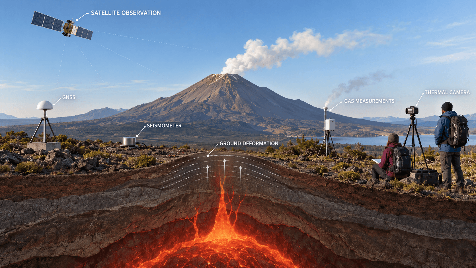
More earthquakes, ground uplift or changing gas composition may indicate magma movement, but not every anomaly ends in an eruption. Scientists assess likely scenarios and update warnings rather than promise an exact eruption date.
Aviation Colour Code versus hazards on the ground
The aviation colour code—green, yellow, orange and red—primarily describes volcanic conditions in relation to aviation hazards and ash. It is not a universal safety indicator for a traveller on the ground. In Iceland, aviation colour codes and ground-level alert systems may differ because they answer different questions. Always read the complete notice, hazard map and local restrictions.
For Iceland, consult the Icelandic Meteorological Office’s earthquake observations. A map helps show where earthquakes occur, but does not replace the observatory’s full notices or emergency-service instructions.
Volcanoes from a traveller’s perspective
You can explore a volcanic landscape without chasing an eruption. Solidified lava fields, calderas, crater lakes, cones, layered lava cliffs, lava caves and geothermal areas reveal a system’s history over a much longer period than one spectacular eruption.
- Check the local observatory, civil protection, road authority and national park notices on the day of your visit.
- Do not cross closures or walk on fresh lava. A thin crust can conceal extremely hot material, and the ground may be fractured.
- Consider wind direction and gas warnings. No visible cloud does not mean no SO₂.
- Do not treat social-media footage as current permission to enter. Conditions and exclusion zones change faster than videos.
- Use official viewpoints and qualified guides where the terrain requires them.
To see how a fissure system, lava fields and day-of-travel checks meet in one region, start with the Reykjanes Peninsula guide. It is a destination guide, not a prediction or an access notice.
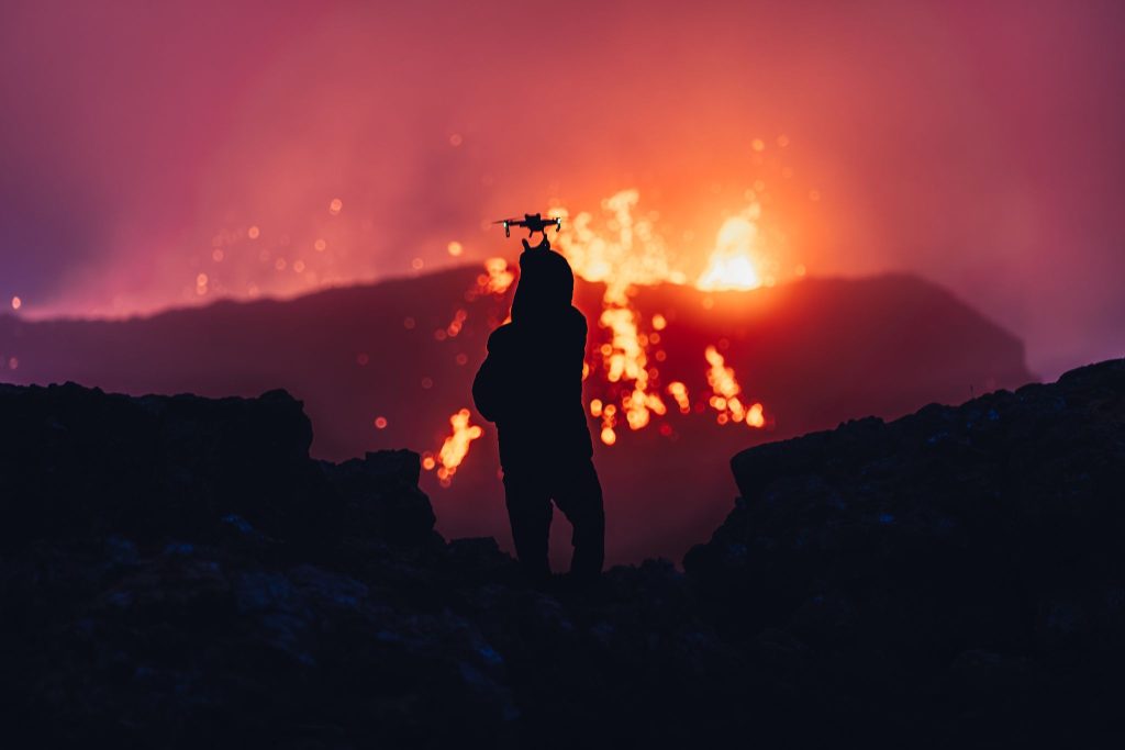
ICELAND VOLCANIC LANDSCAPE
Reykjanes: fissures, lava landscapes and a practical route
Use this destination guide to connect Iceland's fissure volcanism with actual stops on Reykjanes; verify same-day official restrictions separately.
For the documented eruption history at one Reykjanes site, read the Fagradalsfjall eruption guide. Historical reporting is useful context, but it is not a substitute for a current hazard bulletin.
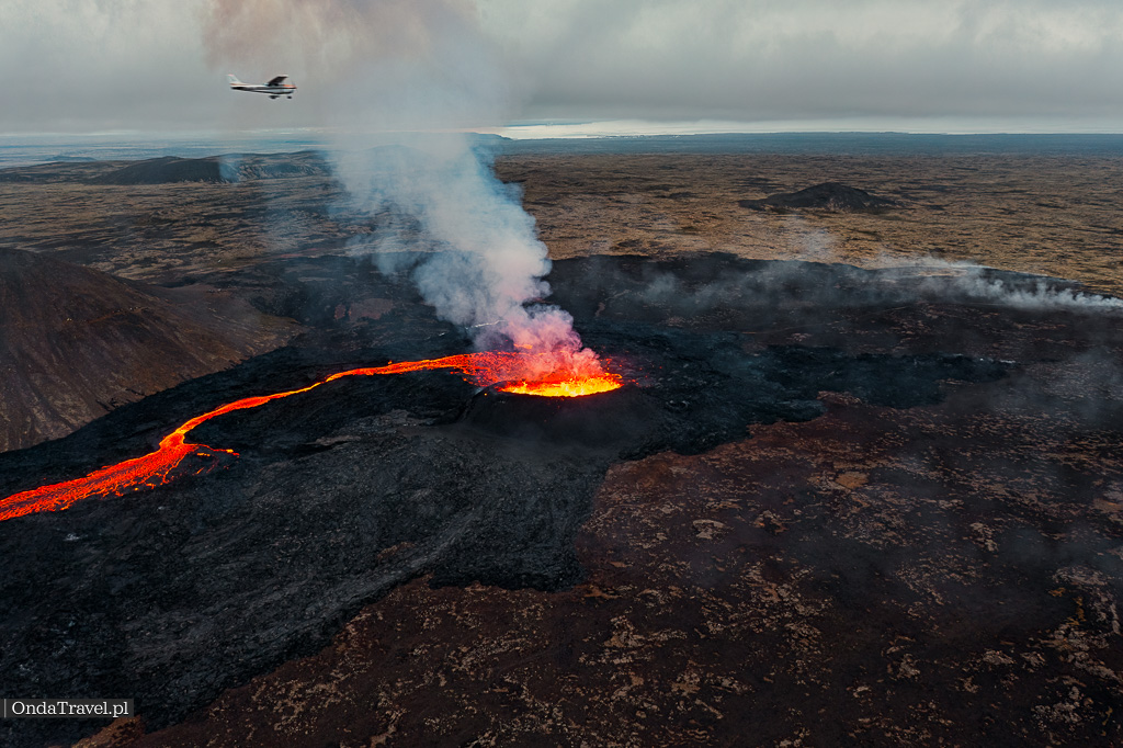
REYKJANES ERUPTION HISTORY
Fagradalsfjall: understand the recorded eruptions
Follow the history and landscape of Fagradalsfjall without confusing a past eruption guide with live access or safety confirmation.
A volcano is more than its visible cone: the former magma chamber at Thrihnukagigur makes that underground system tangible. Its guide covers a booked, guided visit rather than a live-volcano excursion.

VOLCANO INTERIOR
Þríhnúkagígur: descend into a former magma chamber
See how a dormant volcanic conduit relates to the anatomy explained above, then check the practical terms of this guided underground visit.
Steam, mud pots and sulphur at Hverir show geothermal heat at the surface; they are not evidence that an eruption is under way. The place guide focuses on observing the area responsibly.

GEOTHERMAL ICELAND
Hverir: read a geothermal landscape safely
Learn what the fumaroles and mud pots near Námafjall reveal about geothermal activity, with practical visit context rather than eruption claims.
In south Iceland, the Katla Geopark route adds the glacier-covered setting, route conditions and guided cave context that a general volcano explainer cannot provide.

SOUTH ICELAND
Katla Geopark: volcanoes, glacier terrain and route planning
Move from the general hazards of subglacial volcanism to a practical south-Iceland route, including why road and guided-visit conditions need checking.

PLAN AN ICELAND TRIP
Iceland travel guides
Choose the next destination guide after understanding the geology: routes, stops and practical planning are organised separately from this evergreen volcano explainer.
FAQ: common questions about volcanoes
What is the difference between magma and lava?
Magma is below the Earth’s surface. Once it reaches the surface, it is called lava. The distinction concerns location, not a temperature threshold.
Why does a volcano erupt?
Buoyancy and gas pressure help magma rise. It reaches the surface when it exploits fractures or overcomes rock resistance. Viscous, gas-rich magma favours violent fragmentation, while more fluid magma more often produces lava flows.
What is a stratovolcano?
A stratovolcano, or composite volcano, is usually a tall, steep landform built from alternating layers of lava, ash and other eruption products. It can experience both effusive and explosive phases.
Which volcano type is most dangerous?
There is no universal answer. Risk depends on the particular system, magma viscosity and gas content, eruption style, ice or water, terrain and the number of people exposed.
What does VEI 6 mean?
VEI 6 describes a very large explosive eruption using material volume, column height and qualitative characteristics. VEI does not measure every hazard or provide a simple tourist-risk scale.
When is a volcano considered active?
Definitions differ between institutions. Geological databases often consider activity during the Holocene, approximately the past 11,000–12,000 years. This does not mean an eruption is taking place now.
What is a fissure eruption?
Magma emerges along a fracture or series of vents rather than a single central conduit. It can build crater rows and extensive lava fields.
Can a volcanic eruption be predicted?
Monitoring can detect growing unrest and help identify likely scenarios. Usually, however, the exact timing, location and course cannot be specified far in advance.
Sources and further reading
How were the facts checked?
Definitions, classifications and processes are based principally on USGS, the Smithsonian Global Volcanism Program, Poland’s geological survey and ZPE educational resources. Where institutions classify features differently—for example lava domes, or active and dormant volcanoes—the distinction is explained rather than presented as a universal list.
- USGS Volcano Hazards Program: About Volcanoes
- USGS: How do volcanoes erupt?
- USGS: Principal Types of Volcanoes
- USGS: Eruption Styles
- USGS Yellowstone Volcano Observatory: Active, dormant and extinct
- USGS Cascades Volcano Observatory: Volcano Monitoring
- Smithsonian Global Volcanism Program: Volcano definitions
- Polish Geological Institute — National Research Institute (Polish-language source)
- ZPE: educational resources on volcanism (Polish-language source)
Editorial note: classifications depend on the criterion being used. Landform shape, eruption style and activity status answer three different questions and should not be used interchangeably.
Read next




Sorry, the comment form is closed at this time.