


Panama Earthquake 2026 (M7.7) – Epicenter, Aftershocks and Impact
Quick answer
A magnitude 7.7 (Mww) earthquake struck Panama’s Azuero Peninsula at 17:56 UTC (12:56 p.m. local time) on 9 October 2026, according to USGS. The epicenter was 12 km WSW of Pitaloza Arriba, Los Santos province, at a shallow depth of about 12 km. USGS issued a red PAGER alert for economic losses and an orange alert for fatalities; about 4.6 million people felt moderate to severe shaking (MMI V–VIII). Panama’s civil protection agency SINAPROC reported no confirmed deaths and more than 400 damaged buildings. Aftershocks continue — the strongest so far was M 6.6.
Data as of USGS (event us6000u18k, status reviewed, updated 10 Oct 2026 about 10:20 UTC) and Panamanian government statements of 9–10 Oct 2026.
| Question | Short answer |
|---|---|
| How strong was the earthquake? | M 7.7 (Mww) per USGS. Panama’s national network reported 7.2; earlier figures of 7.6 (USGS) and 8.0 (PTWC) were superseded. |
| Where was the epicenter? | 12 km WSW of Pitaloza Arriba, Azuero Peninsula, Los Santos province. |
| Were people killed? | SINAPROC and the CSS social-security health system reported no confirmed deaths and no seriously injured patients; people with minor injuries were treated. |
| Are there aftershocks? | Yes: 43 aftershocks of M 2.5+ in the USGS catalog, including M 6.6 and M 6.0. |
| Is there a tsunami threat? | Check tsunami.gov and SINAPROC. For the strongest aftershock, warning centers said no tsunami was expected. |
The 9 October 2026 earthquake is among the strongest recorded in Panama in the instrumental era. This page brings together verified figures from the U.S. Geological Survey (USGS) and official statements from Panamanian authorities (SINAPROC, the Caja de Seguro Social and the University of Panama’s Instituto de Geociencias). It explains why agencies reported different magnitudes, what a red PAGER alert means, and what travellers should check. Every figure carries its source and time — impact data changes by the hour.

Check out my YouTube channel and travel with me.
Follow the channel for videos, routes and practical travel inspiration.
Follow me here:
What’s up?
Enjoying my content?
Buy me a coffee at buycoffee.to/ondatravel and support the creation of more travel content.
Your support helps me create more practical guides, videos and travel inspiration.

Panama earthquake – latest updates
BREAKING
Editorially maintained log. Each entry shows its source and time (UTC). We add an entry only after a USGS update or a new government statement.
- 10 Oct — SINAPROC, second report: 188 schools damaged (incl. Herrera 48, Veraguas 35, Los Santos 22, Chiriquí 20); about 300 people evacuated from Isla Cañas (Los Santos) because of a rise in sea level; a shelter for 8 families opened in Coclé; still no deaths or missing persons.
- 10 Oct, about 10:20 UTC — USGS: event magnitude stands at 7.7 (Mww), status reviewed; 717 “Did You Feel It?” responses; maximum intensity about MMI IX.
- 10 Oct — Caja de Seguro Social: no deaths or seriously injured patients in CSS facilities; dialysis suspended nationwide, expected to resume on Sunday 11 Oct if conditions are safe.
- 10 Oct, 04:14 UTC — USGS: M 6.0 (Mww) aftershock, 7 km N of La Tronosa.
- 9 Oct, 20:25 UTC — USGS: strongest aftershock so far, M 6.6 (Mww), 14 km W of Río Grande.
- 9 Oct, evening — SINAPROC: no deaths or missing persons; first damage report covering Coclé, Los Santos, Panamá, Darién and Chiriquí provinces.
- 9 Oct, 18:43 UTC — USGS: PAGER assessment — extensive damage probable; about 4.6 million people exposed to MMI V–VIII shaking.
- 9 Oct, 17:56 UTC: mainshock.
Last check: 10 Oct 2026. Current record: USGS us6000u18k.
Seismic map: epicenter and aftershocks
Below is the official USGS ShakeMap intensity map (version 8). It shows the epicenter, the rupture zone and how strongly the ground shook across Panama — most severely (MMI VIII–IX) on the Azuero Peninsula. For a global view, use our Live Earthquake Map, where you can filter tremors by time, magnitude and depth.
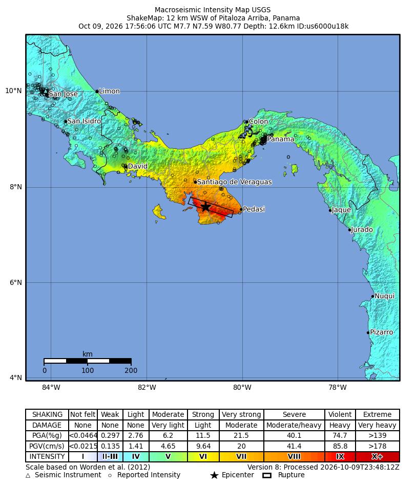
Source: U.S. Geological Survey. Interactive version: event record on the USGS site.
Follow further aftershocks in Panama and worldwide on our live earthquake map (USGS data, refreshed automatically).
Magnitude, depth and the conflicting estimates
Agencies reported different values — normal in the first hours after a large earthquake:
| Source | Magnitude | Type | Status |
|---|---|---|---|
| USGS (current) | 7.7 | Mww (moment magnitude) | reference value, reviewed |
| USGS (earlier) | 7.6 | Mww | superseded |
| PTWC (preliminary) | 8.0 | Mi (rapid estimate) | superseded |
| Panama’s national network (per media) | 7.2 | national network | different method; not directly comparable with Mww |
Rapid methods run within minutes and can over- or underestimate. Moment magnitude (Mww) requires full waveform analysis and best describes the energy of large earthquakes, which is why we use it as the reference value.
| Parameter | Value (USGS) |
|---|---|
| Time | 9 Oct 2026, 17:56:06 UTC (12:56 p.m. Panama time, UTC−5) |
| Epicenter | 7.587°N, 80.769°W — 12 km WSW of Pitaloza Arriba |
| Region | Azuero Peninsula, Los Santos province |
| Depth | about 12.6 km (shallow) |
| Mechanism | left-lateral strike-slip faulting |
| Maximum intensity | about MMI IX (ShakeMap estimate) |
Aftershocks: how many and how strong
A long aftershock sequence followed. The USGS catalog listed 43 events of magnitude 2.5 or greater within 250 km (as of about 10:30 UTC on 10 Oct). Panamanian agencies and media, counting smaller tremors recorded by the national network, reported more than a hundred.
| Time (UTC) | Magnitude (USGS) | Location |
|---|---|---|
| 9 Oct, 18:37 | 5.8 (mb) | 1 km S of El Cacao |
| 9 Oct, 20:25 | 6.6 (Mww) | 14 km W of Río Grande |
| 9 Oct, 23:12 | 5.4 (mb) | 9 km SSE of Los Asientos |
| 10 Oct, 04:14 | 6.0 (Mww) | 7 km N of La Tronosa |
Strong aftershocks can bring down buildings already weakened by the mainshock. USGS warns that further aftershocks, some potentially strong, are likely in the coming days.
Casualties and damage: what Panama’s authorities confirmed
Below is only information attributed to an institution. Figures come from early reports and will change.
| Information | Source | Status |
|---|---|---|
| No deaths or missing persons | SINAPROC (Malitzie Rivera), 9 Oct | confirmed as of the statement |
| No deaths or seriously injured patients in CSS facilities | Caja de Seguro Social (Dino Mon), 10 Oct | confirmed |
| More than 400 damaged buildings | SINAPROC, per media on 10 Oct | preliminary |
| At least 27 people treated for minor injuries | authorities, per media on 10 Oct | preliminary |
| 188 damaged schools; about 300 people evacuated from Isla Cañas | SINAPROC, second report, 10 Oct (via Infobae and EFE) | preliminary |
| 15 students with minor injuries at Alberto Zúñiga school (Coclé) | SINAPROC, first report | confirmed |
SINAPROC’s first report listed damage across several provinces:
- Los Santos — collapsed homes, damaged churches and government buildings, roads, fire and police stations; minor damage to Tonosí and Pedasí hospitals; rising waves at Isla Caña.
- Coclé — partial collapse of the Dos Continentes hotel, damaged facades, churches and roads; one person rescued at the Aguadulce market.
- Panamá — minor damage to four apartment buildings, precautionary hospital evacuations, damage in the Pearl Islands.
- Darién and Chiriquí — light damage to homes, businesses and a school.
Fire stations (including Soná) and IDAAN water-treatment plants were also damaged. We do not publish casualty estimates outside official statements.
What does a red PAGER alert mean?
PAGER is an automated USGS system that estimates impacts minutes after an earthquake from shaking intensity, population and building types. It is a model forecast, not a casualty count.
| Category | Alert | USGS assessment |
|---|---|---|
| Economic losses | red | extensive damage probable; estimated losses 3–30% of Panama’s GDP |
| Shaking-related fatalities | orange | significant casualties likely according to the model |
USGS notes that the region has a mix of vulnerable and earthquake-resistant buildings, including unreinforced brick masonry and adobe. Actual casualty figures come only from the authorities — as of publication they had not confirmed any deaths.
Was there a tsunami threat?
Tsunami threats along the Pacific are assessed by NOAA’s warning centers (tsunami.gov), while SINAPROC issues local instructions. For the strongest aftershock (9 Oct, 20:25 UTC), the warning centers issued information statements saying a tsunami was not expected based on the data and historical records. SINAPROC did report rising waves at Isla Caña. On any coast, follow local orders — after strong shaking, move away from the shore if the water suddenly recedes or rises.
Why does Panama have strong earthquakes?
Panama sits where several plates meet: the oceanic Cocos and Nazca plates to the west and south and the Caribbean and South American plates to the north and east. Together they surround the Panama microplate. USGS says the focal mechanism indicates left-lateral strike-slip faulting, typical of this complex boundary. Most historical activity was further west along the Panama Fracture Zone; notable regional earthquakes include M 7.5 in 1934 and M 7.2 in 1962.
Traveller safety in Panama
If you are in Panama or planning to travel:
- SINAPROC — official hazard statements, evacuations and road closures.
- Tocumen International Airport — check your flight with the airline; we had no official information on either a closure or normal operations.
- Your embassy and your government’s traveller registration service.
- Aftershocks — stay away from damaged buildings, especially on the Azuero Peninsula and in Coclé.
- Water and healthcare — some water-treatment plants and medical services were running with restrictions.
What to do during an earthquake and aftershocks
Strong aftershocks in Panama remain likely for days. Official guidance (Ready.gov, “Drop, Cover, Hold On”):
- Drop to your hands and knees, cover your head and neck, hold on to sturdy furniture until the shaking stops. Do not run outside or stand in a doorway.
- In bed: stay there and cover your head and neck with a pillow.
- Outdoors: stay outdoors; near slopes or cliffs, watch for falling rocks and landslides.
- Driving: pull over in a clear area away from buildings, trees, overpasses and power lines.
- On the coast: after strong shaking, move inland or to higher ground immediately — a tsunami can arrive before any official message.
After the shaking: expect aftershocks, leave damaged buildings and do not re-enter them, keep phone calls for emergencies, and follow SINAPROC statements.
Other extreme events of 9–10 October 2026
The same two days brought three more events that we cover from official sources:
Read next
Pick your next step depending on what you need: live data, background or trip planning.
A global map built on USGS data — follow tremors in any region.

GUIDE
Live Earthquake Map
Filter tremors by time, magnitude and depth.
All our live tools in one place: radars, maps and forecasts.
GUIDE
OndaTravel live tools
Radars, maps and forecasts — context, not official warnings.
Plate tectonics drives volcanoes as well as earthquakes — here are the basics.
VOLCANOES
What is a volcano?
How volcanoes work, their parts and main types.
FAQ
What was the magnitude of the Panama earthquake?
USGS gives M 7.7 (moment magnitude, Mww). Earlier values of 7.6 (USGS) and 8.0 (a preliminary PTWC estimate) were superseded, and Panama’s national network reported 7.2 using a different method.
Where exactly was the epicenter?
12 km WSW of Pitaloza Arriba on the Azuero Peninsula, Los Santos province, at a depth of about 12.6 km (USGS).
Were there deaths in the Panama earthquake?
As of publication, SINAPROC had confirmed no deaths or missing persons, and the Caja de Seguro Social reported no deaths or seriously injured patients. People with minor injuries were treated in hospitals.
How many aftershocks have there been?
The USGS catalog listed 43 aftershocks of M 2.5+ by the morning of 10 Oct (UTC), including M 6.6 and M 6.0. Panamanian agencies, counting smaller events, reported more than a hundred.
What does the red PAGER alert mean?
It is an automated USGS forecast: extensive damage and economic losses of 3–30% of Panama’s GDP are probable. It is a model, not a toll — actual figures come from the authorities.
Is it safe to travel to Panama now?
Check your flight with the airline and follow SINAPROC statements. We had no official information on a closure of Tocumen airport. Avoid damaged buildings and the Azuero Peninsula while strong aftershocks continue.
Sources and limits of this article
- Infobae — SINAPROC second report (10 Oct 2026); EFE via ABC Color — Panamanian authorities’ tally;
- U.S. Geological Survey — event record us6000u18k (magnitude, PAGER, ShakeMap, tectonic summary);
- USGS — PAGER assessment;
- NOAA — tsunami warning centers;
- SINAPROC — statements of 9 Oct as reported by Telemetro;
- Caja de Seguro Social — statement of 10 Oct as reported by Prensa Latina;
- SINAPROC and authorities — 10 Oct tally (400+ damaged buildings, at least 27 with minor injuries) as reported by Libertad Digital.
- Ready.gov — Earthquakes: Drop, Cover, Hold On;
This article reflects USGS data and Panamanian government statements at the times stated. It does not replace SINAPROC instructions. Casualty and damage figures come only from official sources and are updated after new statements.





Sorry, the comment form is closed at this time.