
Face on Mars: What the Cydonia Images Really Show
Explore the Face on Mars, compare the Viking image with later orbital views, and discover how geology, shadows and pareidolia explain Cydonia’s famous formation.
The Face on Mars is a real, natural landform in the Cydonia region. In a famous Viking image, its relief and shadows resemble eyes, a nose and a mouth. Later orbital photographs reveal an eroded hill rather than an artificial sculpture. The face-like impression is an example of pareidolia: seeing a familiar pattern in something that is not actually a face. [1] [2] [8]
| Question | What the evidence shows |
|---|---|
| Is there a real object? | Yes. The hill is a real feature on Mars. |
| Is it a carved face? | Orbital observations support a natural geological explanation. |
| Why does the old picture resemble a face? | Terrain, shadows, limited detail and human pattern recognition work together. |
| Are all the later pictures ordinary photographs? | No. Some products are processed images, perspective views or terrain-model visualisations. |
A face seems to stare out of a grainy photograph of Mars. The outline is striking enough to notice before you know anything about the mission, the camera or the landscape. That first impression made a small part of Cydonia unusually memorable. It also created a misleading question: did later spacecraft make the face disappear? The more useful question is what each image allows us to see. The hill remains; the amount of detail, the viewing geometry and the lighting change. Understanding those differences makes the story more interesting, not less.
Contents
- What is the Face on Mars, and where is Cydonia?
- What does the original Viking picture actually show?
- How do the later images change the picture?
- Why do we see a face in a landscape?
- Were the newer pictures retouched?
- What do the terrain model and moving shadows show?
- What about the pyramids and the supposed city nearby?
- How to read a Face on Mars comparison
- Face on Mars: questions and answers
- Sources

Check out my YouTube channel and travel with me.
Follow the channel for videos, routes and practical travel inspiration.
Follow me here:
What’s up?
Enjoying my content?
Buy me a coffee at buycoffee.to/ondatravel and support the creation of more travel content.
Your support helps me create more practical guides, videos and travel inspiration.

What is the Face on Mars, and where is Cydonia?
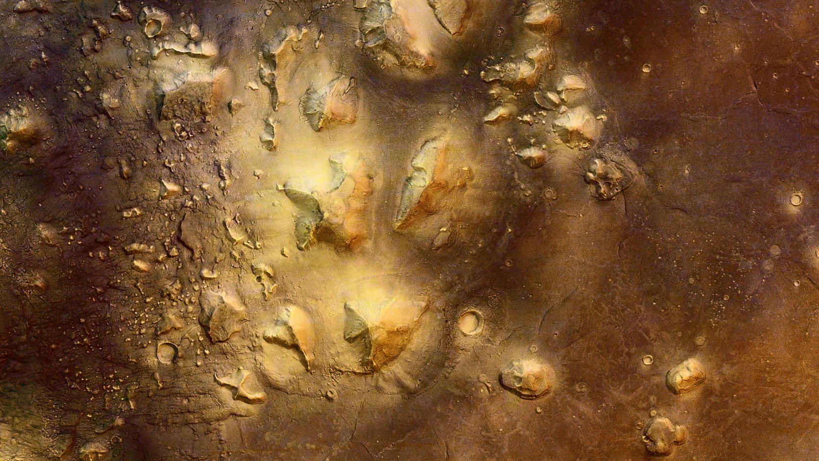
Cydonia is a region, not the name of a single monument. The famous “face” is one landform among other hills and remnants of older terrain. Wider views are important because an isolated crop can make an ordinary landscape feature seem unique. The regional geological setting provides context that a face-shaped thumbnail cannot.
The term mesa is often used to describe the formation: an elevated remnant with a relatively flat upper surface and eroded sides. Calling it a natural landform does not require pretending that every detail of its geological history is settled. It means the observed structure belongs to the surrounding landscape, rather than providing evidence of a constructed sculpture. [2] [3] [7]
What does the original Viking picture actually show?
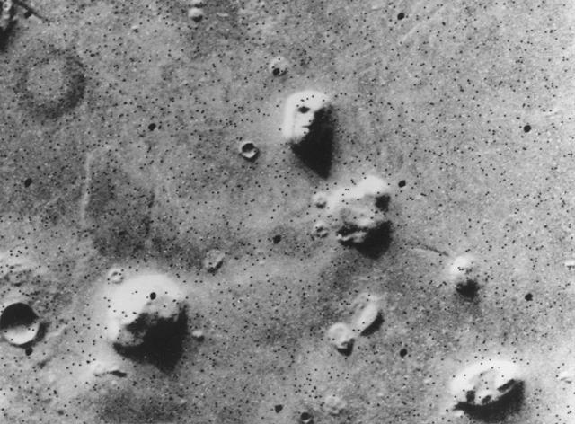
The historical image records a real hill, but it is not a complete description of the hill. Ridges, slopes and shadows combine into a small number of bright and dark shapes. A viewer can readily read those shapes as facial features. NASA’s original explanation already connected that appearance with natural relief and illumination; the scientific account was not invented only after the image became famous.
Some dark points in the historical image also reflect missing data rather than holes in the ground. That detail matters when a heavily enlarged crop is treated as a precise portrait. It does not mean a single damaged pixel explains the entire resemblance. The impression comes from the image as a whole. [1] [10]
How do the later images change the picture?
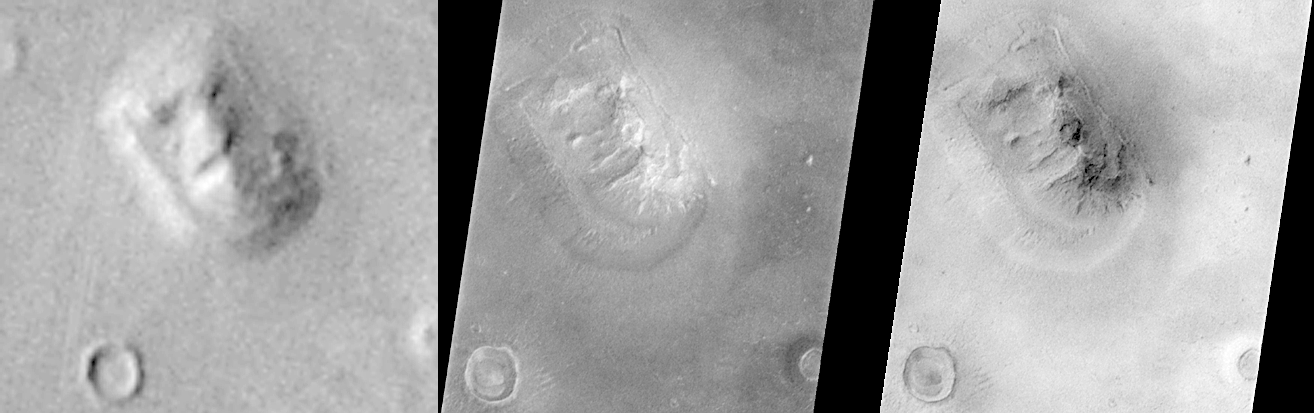
Mars Global Surveyor’s camera supplied more detailed views of the same feature. Mars Express placed it in a broader landscape, while HiRISE revealed still finer surface structure. Together, these observations allow the viewer to examine slopes and irregularities that the famous Viking frame cannot resolve.
A useful comparison therefore asks whether the panels show the same feature, have compatible orientation and include a scale. Simply enlarging two crops to the same rectangle can create a false sense that they are directly equivalent. Different lighting can strengthen or weaken a face-like pattern without changing the underlying hill.
There is also no need to insist that every modern image must stop looking like a face. A viewer may still recognise a face-like outline. The relevant scientific question is whether the detailed terrain supports an artificial construction. The later images support the natural explanation. [2] [3] [4]
Why do we see a face in a landscape?
Pareidolia is the perception of a meaningful, familiar form in an ambiguous pattern. Face pareidolia includes noticing eyes and a mouth in everyday objects, rocks or clouds. It describes a normal feature of perception, not a diagnosis or a claim that someone is foolish.
The geological and perceptual explanations answer different questions. Geology addresses what the hill is. Pareidolia helps explain why an arrangement of shapes is recognised as a face. Research on face perception supports that distinction, but it should not be presented as an experiment conducted on everyone who has looked at the Viking photograph. [8]
Were the newer pictures retouched?
Scientific images are often processed so that they can be interpreted and compared. Contrast adjustment, orientation correction and map projection are not automatically evidence that an object has been removed. The camera team’s documentation matters more than the vague label “edited”.
The Mars Orbiter Camera release explains different products and processing steps. Some raw products have an orientation that differs from corrected versions. Before interpreting a left–right difference as a change in the landscape, check which product is being shown. A responsible comparison identifies the spacecraft, instrument, image record and any actual cropping or transformation. [4]
What do the terrain model and moving shadows show?
A digital terrain model reconstructs the shape of the surface from suitable observations. The HiRISE presentation uses such a model to explore the formation under changing illumination. It is useful for seeing how shadows contribute to the familiar appearance.
The distinction between evidence and presentation remains important. A rendered flyover is not a photograph taken by a rover, and a sequence of simulated shadows is not a camera recording the entire day from a fixed spot on Mars. The model is an interpretation built from observations, with its own method and limitations. It should be labelled accordingly. [5] [6]
What about the pyramids and the supposed city nearby?
Some neighbouring landforms received names that evoke buildings. The best-known example is the so-called D&M Pyramid. A geometric-sounding name does not establish an artificial origin. The published camera-team description places the feature in a natural geological setting with other remnants of terrain.
The same caution applies to a supposed city drawn by connecting selected shapes. A convincing archaeological claim would need evidence beyond a resemblance in an orbital crop. The Cydonia observations discussed here do not supply evidence of a constructed face, pyramid complex or city. [7] [9]
How to read a Face on Mars comparison
Start with the full scene, then inspect the crop. Check the spacecraft and instrument instead of assuming that every Mars image comes from the same camera. Distinguish the date an observation was acquired from the date a web page was published. Finally, identify whether the panel is an orbital image, a processed image, a perspective reconstruction or a model.
These checks are particularly useful when a dramatic caption says that the face was erased, rediscovered or photographed from the surface. The strongest comparison is the one that explains the differences between products, not the one that conceals them. The original mission records linked below provide a better starting point than an unattributed montage. [1] [2] [4] [5]
Read next
Guides and calendars for planning sky observations.
GUIDE
Sky phenomena
Guides and calendars for planning sky observations.
Face on Mars: questions and answers
Is the Face on Mars real?
Did NASA originally describe it as an alien monument?
Did the face disappear in later images?
Why can I still see a face in a detailed image?
Recognising a familiar shape does not establish how the object formed. Pareidolia can remain convincing even when its natural explanation is understood. [8]
Is Cydonia another name for the hill?
Did a European spacecraft observe it too?
Yes. Mars Express and its HRSC camera provided images of Cydonia and the surrounding landscape. [3]
Does image processing prove the photographs are fake?
No. Evaluate the documented processing and the original products. Processing alone is not evidence of concealment. [4]
Is the shadow animation a rover video?
Are the nearby pyramids artificial?
Where should I check the images myself?
Use the NASA/JPL, HiRISE, MSSS and DLR records in the source list, keeping the image identifier and product description with each comparison.
Sources
Sources
1. NASA/JPL — Geologic “Face on Mars” Formation
2. HiRISE — Popular Landform in Cydonia Region
3. DLR — Cydonia region with the so-called Face on Mars
4. MSSS — Mars Orbiter Camera Views the “Face on Mars”
5. HiRISE — Sunrise to Sunset on the Martian Mimetolith
6. HiRISE — Digital terrain model for Cydonia
7. USGS — Geologic map of Cydonia Mensae
8. Wardle and colleagues — Rapid and dynamic processing of face pareidolia in the human brain
9. NASA/JPL — The Cydonia “D&M Pyramid” Landform
10. NASA/JPL — original Viking image caption P-17384 (1976), MSSS archive
Author
Krystian „dziadzia przewodnik”The North is my greatest passion, but the world is too beautiful to stay in one climate. On my blog I combine the raw nature of Iceland and Norway with the exotic energy of Thailand and Vietnam, showing you how to travel authentically, with passion and a camera in hand.