Norway Senja Island above the Arctic Circle – Tromso Norway – What to See
Senja Island & Tromsø above the Arctic Circle: what to see and where to go
Senja is Norway’s second-largest island in Northern Norway’s Troms region, just north of the Lofoten Islands. It’s known for dramatic fjords, sharp peaks, and surprisingly easy roadside viewpoints — and many travelers combine it with a few days in Tromsø for flights, city comforts, and Arctic tours. If you’re building a longer itinerary, see Norway trip planning guides for routes, seasons, and practical tips.

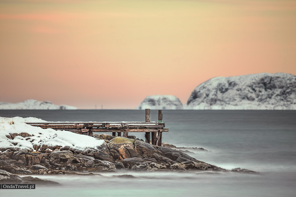
Senja’s wild coast near Steinfjord — one of the most photogenic stops on the Senja scenic route.
Senja & Tromsø – Table of contents


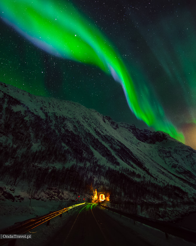
Northern Lights on Senja: best viewpoints, timing and simple tips
Senja, thanks to its location above the Arctic Circle, is a fantastic place to look for Northern Lights (aurora borealis). For the best odds, stay flexible, pick a dark viewpoint away from village lights, and check cloud cover plus geomagnetic activity — I usually start with Northern Lights radar: locations and forecasts. If you’re planning a bigger winter loop in Northern Norway, you can also add the Arctic Northern Lights Train from Narvik as a scenic extra.


Senja highlights to visit: scenic route, beaches and viewpoints
Here are some interesting facts about Senja:
- Senja covers about 1,586 km² and is often described as Norway’s second-largest island (after Hinnøya).
- The island’s highest point is around 1,000 m (Breidtinden) — enough for dramatic ridgelines, but still very hike-friendly with the right weather window.
- Senja is known for fishing villages and harbors like Mefjordvær, Husøy, and Fjordgård — plus small beaches and fjords squeezed between steep mountains.
- The Senja Scenic Route (National Tourist Routes) is packed with easy viewpoints — especially Bergsbotn and Tungeneset.
- In winter, long dark hours make Senja great for aurora hunting; in summer you get very long days for road trips and hikes.

On Senja you can find many attractions and places to visit, including:
- Ånderdalen / Anderdalen National Park: Anderdalen National Park is an area with rich flora and fauna. You can find various tourist paths and hiking trails here.
- Mefjordvær: This is a charming fishing village where you can admire picturesque landscapes and enjoy peace and quiet.
- Husøy: This is a small island with colorful fishing houses, located off the coast of Senja. It’s a beautiful place for walks and photography.
- Bergsbotn: A village located by a beautiful fjord, perfect for hiking and observing wildlife.
- Tungeneset: This place offers a beautiful view of the sea, mountains and glaciers. It’s a great place to observe the Northern Lights.
- Hiking trails: Senja offers many hiking trails that allow you to explore the island on foot. You can climb the Segla summit, which offers a magnificent panorama of the area.
- Fjords: The island is surrounded by beautiful fjords, such as Ersfjorden and Bergsfjorden, which are excellent places for photography and relaxation.


Senja fjords and coastal stops: Skrolsvik, Hamn and wild beaches


Skrolsvik Fort, also known as Skrolsvik Coastal Fort (Norwegian: Skrolsvik fort), is a coastal defense site at the southern tip of Senja, in Senja municipality (Troms county, Northern Norway). Built during World War II and later expanded in the Cold War, it’s a quick history stop with sea views — check local access and opening info before you go.


After the war, the fort was taken over by the Norwegian armed forces and was used as an anti-aircraft battery until 1989. Currently, the fort is abandoned, but it is a popular place for hiking and trekking.
The fort consists of 12 bunkers that are connected by an underground tunnel system. The bunkers were equipped with heavy anti-aircraft guns that were intended to protect the port in Finnsnes from air attacks. The fort was also equipped with radar and other anti-aircraft defense systems.


Hamn Village on Senja Island in Norway has a rich history dating back to the times of fishing and hunting in the area. The history of Hamn village dates back to the Viking times, when this region was inhabited by sea traders and fishermen.Hamn is a former fishing settlement that over the years has evolved into a picturesque tourist destination, attracting both nature lovers and travelers seeking peace and quiet.
The history of Hamn village is deeply connected to fishing, which was the main source of livelihood for the inhabitants. People were primarily engaged in cod fishing, which was abundant in the surrounding waters.


Ersfjord Beach Ersfjordstranda / Berg on Senja Island in Norway is considered one of the most beautiful beaches in Norway, thanks to its white sand, turquoise sea and the majestic mountains surrounding it. This beach is located in Ersfjorden Bay, in the western part of Senja Island, about 10 kilometers from the town of Finnsnes.. This place is popular not only in summer but also in winter, when the entire area looks magical covered in snow.
Bergsbotn Viewpoint is a popular tourist attraction located on Senja Island in Norway. The viewpoint is located 44 meters above sea level, and from it there is a view of mountains, fjords and the sea.

Viewpoint Gryllefjord is a popular tourist spot on Senja Island in Norway. The viewpoint is located at the end of road 86, about 10 kilometers from the town of Gryllefjord. From the viewpoint there is a beautiful view of Gryllefjord fjord, mountains and islands. Near the viewpoint there is also a restaurant and a campsite.
Tungeneset is a viewpoint on Senja Island in Norway. It is located in the north of the island, on the peninsula separating Ersfjord from Steinsfjord. The viewpoint offers a spectacular view of the Norwegian Sea, Okshornan mountains and Gryket island.

Okshornan or Oksen “Devil’s Jaw” is a mountain range with three distinct mountain peaks located on the west coast of Senja Island, in northern Norway. The highest peak is Store Okshornet, 559m above sea level. The next two Kjølvamannen is a peak on Kjølva and Storkwænen is one of the peaks of kvæn. They are often called “Devil’s Horns”, “Devil’s Teeth” or “Devil’s Jaw” due to their characteristic shape.


Segla Mountain hike: trail, time needed and viewpoints
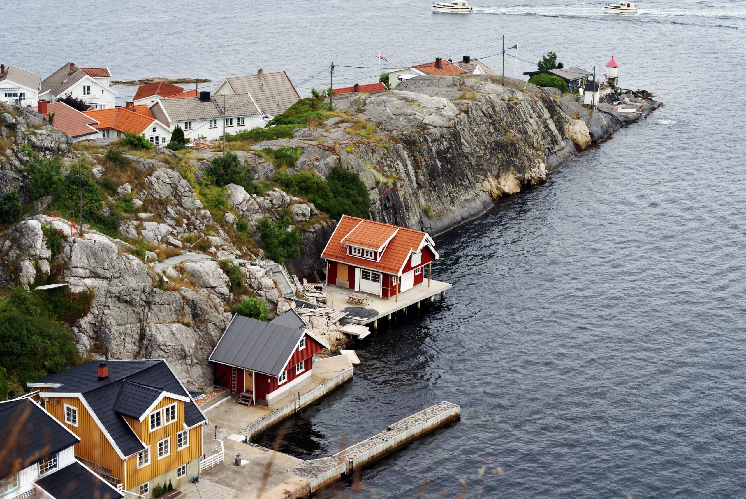
Husøy is a small fishing community in Senja municipality (Troms county), set on a tiny island in Øyfjorden and connected to the main island by a bridge. It’s a great stop for photos of colorful houses, a working harbor, and sharp peaks rising straight from the fjord — especially in calm morning light.


Segla Summit is located near the village of Fjordgard on Senja.
Mount Segla has a characteristic shape that resembles a sail, hence its name, which in Norwegian means “sail”. The summit is about 640 meters above sea level. The most popular climbing route leads to the summit from the village of Fjordgård, and the trail leads through diverse terrain, including rocky sections and slopes. Although the climb is not particularly technically difficult, the terrain can be challenging,
Description of the trail to Segla summit
Hesten Mountain (Horse): Hesten is a mountain whose name in Norwegian means “horse”. It is a peak with a characteristic shape that resembles the silhouette of a horse.From the summit we admire Segle
Description of the trail to Hesten summit
Like Segla, Hesten has a steep drop to the fjord below, but it is not as high, measuring 556 meters above sea level. In addition to Segla, Hesten offers magnificent views of Mefjorden to the west and Inste Kongen mountain and Korkedalen valley to the north.
Senja Island – Frequently Asked Questions – Senja what to see
Where is Senja Island located?
Senja is the second largest island in Norway, in the Troms county region, north of the Lofoten Islands.
How to get to Senja
By car from Tromsø (approx. 3-4 hours) or by ferry in summer from Tromsø and Lofoten. The island is connected to the mainland by the Gisundbrua bridge.
Why is Senja called “Norway in miniature”
Because it combines fjords, mountains, beaches, forests and traditional fishing villages – it encapsulates all of Norway’s landscapes in a nutshell.
What are the main attractions of Senja? Senja attractions
Senja National Tourist Route, Tungeneset and Bergsbotn viewpoints, Ersfjord and Bøvær beaches, and numerous mountain trails.
Senja – what to see in Tungeneset?
Tungeneset is a wooden viewing platform leading to the rocky coast, from which there is a view of the dramatic Oksen mountains and the Arctic Ocean.
Senja – what distinguishes Husfjellet
Husfjellet is one of the most beautiful trekking trails on the island. From the summit, there is a panorama of Bergsfjord and Steinfjord fjords.
When is the best time to visit Senja
Summer (June-August) for trekking and sightseeing. Winter (December-March) for the Northern Lights and peaceful atmosphere.
Is Senja less crowded than Lofoten?
Yes, the island is quieter, less touristy, and the landscapes are equally spectacular.
How many days should you spend on Senja?
2-4 days are enough for the main attractions. A longer stay (5-7 days) allows you to discover more trails and beaches.
How to prepare for a trip to Senja?
It’s best to rent a car – public transportation is limited. You need clothing for changeable weather and good hiking boots.
Tromsø: Arctic base for Senja, fjords and winter aurora trips
Tromsø is one of Northern Norway’s best bases for Arctic adventures, located above the Arctic Circle in Troms county. The city sits between fjords and mountains on and around Kvaløya and is connected to the mainland by bridges and tunnels — which makes it easy to combine city time with short drives to viewpoints, beaches, and aurora spots.

Tromsø history in brief: from trading town to “Gateway to the Arctic”
The history of Tromsø dates back to the distant past and is connected with fishing, trade and Arctic research. Here is a brief history of Tromsø in Norway:
Beginnings and development of fishing: Tromsø was founded in 1794, and initially it was a small fishing town. It was strategically located on the waters of the Norwegian Sea, which favored the development of fishing and fish trade.
Trade and Arctic exploration: In the 19th century, Tromsø became an important trading center and also a base for Arctic expeditions. Research expeditions, such as those of Fridtjof Nansen, were based in Tromsø, which strengthened the city’s position as an important point in Arctic research.
Status as a polar place: Due to its location above the Arctic Circle, Tromsø became an important place for researchers and travelers heading north. The city gained a reputation as the “gateway to the Arctic” and became the starting point for many expeditionary voyages.
Development as an educational and cultural center: In the 20th century, the city began to develop as an educational and cultural center. The University of Tromsø was founded in 1968 and contributed to increasing the city’s importance as an academic center.
Tourism and industry: In recent decades, Tromsø has become a popular tourist destination, especially for observing the Northern Lights. The tourism industry has become increasingly important for the local economy.
Today’s Tromsø: Today, Tromsø is a dynamic city with a rich history and culture. It is known as the capital of the Arctic and still attracts researchers, tourists and people interested in life in extreme conditions.
What to do in Tromsø: cable car, museums and fjord panoramas
Storsteinen Viewpoint on Fløya Mountain (420 m above sea level). : You can reach it by cable car (Fjellheisen) and see a breathtaking view of the city, fjords and surrounding mountains.
Arctic Cathedral (Ishavskatedralen): This is a distinctive place in Tromsø, known for its unique architecture resembling a glacier or igloo. The cathedral offers a beautiful interior and magnificent views of the fjords and mountains.
Polaria: Polaria is an educational and exhibition center dedicated to Arctic nature. Here you can learn about the life of Arctic animals, see an aquarium with marine creatures and watch documentary films.
Tromsø Fjellheisen is one of the biggest tourist attractions in northern Norway. This cable car will take you to a height of 421 meters, from where there is a breathtaking view of the city of Tromsø, the surrounding fjords and majestic mountains.
Ersfjordbotn Village in the municipality of Tromsø in the county of Troms Og Finnmark, specifically on the island of Kvaløya, near Tromsø. One of the most characteristic features of Ersfjordbotn is Ersfjorden Fjord, which together with the surrounding high mountains and trails Djeveltanna,Storsteinnestind, Kvaløysletta, Norway creates an amazing combination.


A quick visual taste of Senja & Tromsø — viewpoints, fjords, and Arctic light.
Tromso – Frequently Asked Questions – Tromso what to see
Where is Tromsø located?
Tromsø lies in northern Norway (Troms county), above the Arctic Circle.
How to get to Tromsø from Poland?
The simplest option is to fly to Tromsø (often via Oslo). Seasonal direct flights may also be available, depending on the year.
When is the best time to visit Tromsø?
September–March is ideal for Northern Lights trips, while May–July is best for the midnight sun and summer hikes.
Tromsø – when can you see the Northern Lights?
Aurora season usually runs from September to early April. Aim for clear, dark nights and get away from city lights.
Tromsø – what attractions are worth seeing?
Arctic Cathedral, Fjellheisen (cable car panorama), Polaria, the Polar Museum, fjord cruises and easy hikes around the city.
How many days should you spend in Tromsø?
2–3 days is enough for the city itself. With Northern Lights tours and fjord day trips, 4–5 days is a comfortable plan.
Is Tromsø expensive?
Yes — accommodation, food and tours can be pricey, as in most of Norway. Booking early helps a lot.
How to get around Tromsø?
The city centre is easy on foot. Use local buses for longer distances, and join tours or rent a car for fjord trips.
Does Tromsø experience polar night?
Yes. From late November to mid‑January the sun stays below the horizon, but you still get a few hours of twilight.
How to prepare for winter in Tromsø?
Pack layers, a warm insulated jacket, winter boots with good grip, and accessories to protect against wind and frost.
- Senja Norway tourist guide
- what to see on Senja Island Norway
- attractions of northern Norway Senja
- Senja Island Norway travel plan
- Senja Norway photography spots
Read also / next
- Norway travel page: maps and practical guides for planning
- All destinations in English: countries and key guides in one place
- Northern Lights radar: locations, forecast basics and what to watch
- Travel on OndaTravel: destinations, country hubs and route planning


Hi, I’m Krystian “dziadzia przewodnik” from OndaTravel.pl!
The North is my greatest passion, but the world is far too beautiful to stay in just one climate. On my blog, I combine the raw landscapes of Iceland and Norway with the exotic energy of Thailand or Vietnam, showing you how to travel authentically — with passion and a camera in hand.
What will you find on OndaTravel.pl?
Visual storytelling: As a photographer and filmmaker, I don’t just describe places — I take you there with professional photos and video.
North expert: Ready-to-use road trip plans for Iceland and Norway, smart tips for budget travel, and my original Northern Lights Radar (locations and forecast).
Travel through the lens of cinema: I track down filming locations — from icy scenes in Interstellar to tropical frames from world cinema.
New direction: Exotic destinations: I love contrast, so the blog is featuring more and more practical knowledge about Vietnam and Thailand. I’ll show you how to find your way around Southeast Asia and come back with your best memories.
P.S. follow me here
Excerpt: Senja and Tromsø are two of Northern Norway’s most scenic stops — fjords, fishing villages, easy viewpoints, and long Arctic light. This guide covers what to see, how to plan the drive, and where to chase the Northern Lights.